Weather - Clouds - Formation

Useful Links
Downloadable Materials
How Clouds Form
Clouds form when the air cools to the dewpoint (the temperature at which air becomes saturated and the previously invisible water vapour condenses into tiny droplets).
Cooling occurs in two basic ways:
- air either comes into contact with a cold surface (the will occur when moist air passes over cold land or sea to give low stratus cloud) or rises in the atmosphere (air may rise when there is convection caused by heating, it is forced over hills or mountains or if it encounters colder, denser air).
- Another process, convergence, occurs when air is forced into a restricted area. Some of the air must rise to escape.
Stability
Warm air rises, expands and cools. How far it moves depends on the surrounding air. If this is relatively warm it has a lower lapse rate, so the rising air cools faster than its surroundings. When it reaches the same temp. as its surroundings it stops. Such conditions are said to be stable and lead to the formation of stratiform clouds if the rising air does not reach the dewpoint.
If however the surrounding air is relatively cold a rising parcel of air may remain surrounded by colder air and continue to rise. The conditions are unstable and result in cumuliform clouds. The rising air may even accelerate, especially if it reaches the dewpoint and condensation occurs.
Instability (and cumulus clouds) are often found in cold air flowing over a warm sea. Warm air moving over cold land, by contrast, is stable and frequently produces low stratus cloud. An inversion is a layer where temperature increases with height, so inversions are layers of extreme stability. They often cause the upward growth of clouds to come to a halt.
Stratocumulus and altocumulus often arise when cumulus clouds encounter and inversion.
Inversions
Temperature tends to decrease with height (at least in the lower reaches of the atmosphere). The rate at which the temperature falls (called the lapse rate) averages about 6 °C per km. However this rate is not constant (as the air consist of various layers of different temperatures and humidities). In certain layers, known as inversions, temperature actually increases with height.
A major inversion, called the tropopause, defines the boundary between the troposphere and the overlying stratosphere. Above the tropopause, temperature increases rapidly throughout the stratosphere, up to about 50 km (mainly because ozone absorbs a great deal of UV radiation from the Sun).
The tropopause height depends on latitude and season but is at about 16-18 km over the equator, 11-12 km at middle latitudes and around 8-9 km over the poles.
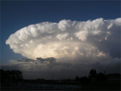
The tropopause limits the growth of the most vigorous cumulonimbus clouds, and forces them to expand sideways into large cirrus anvils (it is not a complete barrier though).
Air conducts heat poorly. Once away from the surface a parcel of air cools or warms almost independently of it surroundings. The rate at which rising air cools depends on the amount of water vapour present. All air contains water vapour but when it is above its dewpoint no water droplets are present and it is described as 'dry'. Dry air cools at around 10 °C per km.
Because heat is needed to evaporate water the reverse process, condensation, releases this latent heat. Once air has cooled to the dewpoint, cloud droplets form and the heat released reduces the rate of cooling. As a result, saturated air cools at a lower rate, about 5 °C per km.
Convection
Convection is a familiar process and occurs when a gas or liquid is heated from below. In the atmosphere it is responsible for most of the pressure differences. Above ground heated by the Sun or other sources, invisible bubbles of warm air (thermals) break away from the surface and rise up. The thermals expand and cool as they rise and eventually reach the dewpoint.
The type of cloud that then forms depends entirely upon the way in which the temperature of the surrounding air varies with height and upon whether the air is stable or unstable. Convection generally produces cumuliform clouds but may produce stratocumulus and altocumulus.
Orographic Clouds
These are clouds formed by forced uplift over hills or mountains. The cloud type depends on the stability. Just as air cools when it rises it also warms at the same rates when it descends. On the sheltered side of hills and mountains cloud droplets evaporate and any cloud tends to break up and disperse.
With the right combination of stable conditions, trains of waves may be set up, bringing air down from upper warmer levels in the shelter of the mountains. This may be warmer and dryer than air at the same height on the windward side and this will cause a dramatic temperature rise accompanied by extremely dry air and the rapid disappearance of snow (the 'fohn' effect).
When conditions are unstable, cumuliform clouds form.
In the final process of cloud formation, cold air lifts warm air away from the surface. This occurs at the warm and cold fronts of depressions.