Mapping - Coordinates or Grid References

Reproduced by kind permission of the Ordnance Survey. MC 99/91
Useful Links
Downloadable Guides
![]() Grid References - 6 Figure & Bearings
Grid References - 6 Figure & Bearings
![]() Map Ready Reckoner by Graham Williams, 12th Andover West
Map Ready Reckoner by Graham Williams, 12th Andover West
Introduction
Coordinates are a mathematical way of defining a point or a region. They usually rely upon a numbered grid system, and an agreed method to pin a particular point down. This sections aims to introduce and teach the basic concepts and skills required for using map coordinates

Aqua 3 Maps
Weatherproof, Tough & Durable, Anti-glare, Write on/Wipe off, Lightweight AQUA3®
Free Post & Pack
Aqua 3 sell special all weather maps. These are coated with a special waterproof material and prove to be very useful in the poorest of weathers.

Get 10% off all Ordnance Survey Maps and free UK Postage & Packaging on all OS Maps orders
Map Basics
We will begin with an example. A typical (Ordnance Survey Landranger 1:50 000) map reference could be:
HQ 765459
HQ refers to a very large area of the map (100 000 metre squares), and should be marked in large blue letters on your map. This is not usually necessary if it is clear which map everyone is using.
The remaining 6 figures detail a point (actually an area around 100x100 metres due to estimation). They are quoted in a particular order. The first three represent how far across the map you are (from left to right). The last three details how far up the map you are (from bottom to top).
There are three numbers for each of these because the first two tell you which grid square (the blue grid squares are 1 km x 1 km) you are in, and the third number gives you more accurate information about how far into that square the point is.
Advanced Note
The only true representation of the earth, free of distortion, is a globe (sphere). But of course maps need to be flat to be practical and the process by which they are transformed from their real life location (geographic, e.g. latitude and longitude) to a flat two-dimensional map is called a projection. There are many types of projection and each serves a unique purpose.
In practice converting from the 3-d sphere to a 2-d piece of paper will result in some 'distortion' no matter how you do it. Perhaps the size of the country will be distorted. Perhaps the lengths across the map represent different lengths in real life depending upon where the line is.
Of course for the map to be useful the distortion must be small, at least on the scale the map is representing. If you look at a typical Ordnance Survey Landranger map you will notice a map symbol which looks like a light blue cross (Graticule Intersection at 5' intervals). These mark out lines of latitude and longitude on the surface of the Earth (sphere). These help give an indication of the 'distortion' of the map compared to 'real life' features on the curved surface of the Earth.
To help you imagine this take a look at the pictures at the following site. - Geosystems
The graticule intersections form the boundary of the 'square' grid on the surface of the Earth. The map is then projected onto the flat sheet of paper so that now these graticule intersections do not quite form a perfect square on the map. However you will notice that the distortion is small and across the map is quite sufficient for almost any purpose.
Four Figure Grid References
If you simply want to pin down which (1 km x 1 km) square you are in, i.e. the general area, then a four figure reference may be used. This will produce two lines that intersect at a point (remember, first two are along, second two are up). The square that you want is the one on the top right (if two lines intersect at a cross, then in theory there are four squares that could be represented by this reference).
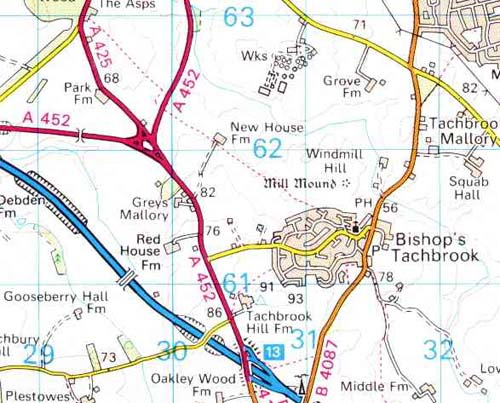
Try looking at the examples below.

Reproduced by kind permission of the Ordnance Survey. MC 99/91
Bishop's Tachbrook: 3161
Park Farm: 2962
Motorway Junction with A452: 3060
Wks (Works): 3062
Gooseberry Hall Fm: 2960 (The 60 mark is just off the bottom of the map)
Six Figure Grid References
A six figure grid reference is normally the one you would choose to use to locate a point (say a building). A four figure reference simply pins the region down to a 1 square kilometre area, not very useful if you want to find the post office. As a (very) rough guide, a square kilometre area is around the size of a small village. To quote a six figure reference, you first locate the square that you are interested in (as above in four figure references). We then imagine dividing that square into 10 equally spaced intervals along and up the square. This would form an imaginary grid of 100 squares within the blue grid square. We then quote a further reference using these numbers. For example, an object in the exact centre of a square would have a reference along the lines of
something something 5 something something 5
The first two numbers would be the eastings of the grid square, the second two 'somethings' would be the northings of the grid square. The 5 and 5 are there because it would be 5 in and 5 up within the blue grid square (i.e. in the centre). For ease of use, when we write this, we write all the eastings together, then all the northings together.
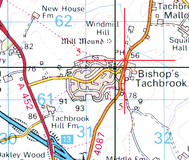
Take a look at the example below and see if it helps. Here we are trying to find the six figure grid reference of the church with a tower in Bishop's Tachbrook. The black lines, and red lines and red numbers have been overlaid on the map to help visualize the coordinates. The red lines represent a distance of 5 tenths of way into the square (in other words halfway) horizontally and vertically.

Reproduced by kind permission of the Ordnance Survey. MC 99/91
314614
Eastings First (Vertical Lines) - 31 - How many large blue grid squares it is along. The first 4 represents how many tenths of a square is is along.
Think of it as 31.4 across
Northings Second (Horizontal Lines) - 61 - How many large blue grid squares it is up. The last 4 represents how many tenths of a square it is up.
Think of it as 61.4 up
Note: Map colours are not true to original map due to colour reduction to keep download time to a minimum. I have added the red lines to show the 5 tenths mark of the grid square (i.e. halfway mark of the square) to aid estimation of the tenths.
Further examples are (now I will write the six figure reference in the same pointsize):
Mill Mound: 314617
New House Fm: 304621
Note: Obviously in these examples I have taken care to choose a portion of the map with the large blue grid line markers on for ease of use. Generally speaking you will have to search a little to find the number of the line that you are interested in. The grid numbers are repeated at regular intervals across the map, and can always be found at the edges of the map.
Where Wolf
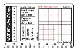
Where Wolf produce a credit card sized plastic aid to map reading. The card is mainly transparent plastic which has a Roemer scale for the most common OS maps (Explorer and Landranger). This makes it easy to overlay the card on the map and read off the 6 figure grid reference with ease.
Printed on the card is also a reminder of how to quote OS grid references and a ruler along one edge.
The Where Wolf makes a good gift for Scouts and many of the leaders in my District have been impressed by it and have placed their orders with me for a bulk load of them.
Visit http://www.where-wolf.com/ for more details and special offers.
